Killarney Project
The Killarney Project is located approximately 63km east of Mount Magnet and 8km north of the former Paynesville townsite. Access to the Killarney Project from Mount Magnet is via the Mount Magnet-Sandstone Road to the historic Paynesville townsite, then north along the Mount Magnet – Windsor Road for 5km, the last 8km is via station tracks to the northwest.
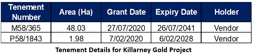
Tenements
The tenements are held 100% by the Vendor and the details are listed below.
Geology
P58/1843 and M58/365 fall within the Murchison Domain of the Youanmi Terrane of the Yilgarn Craton and cover part of the Meeline Suite of the Windimurra Igneous Complex. The Windimurra Igneous Complex (WIC) is a large mafic-ultramafic layered intrusion, dominantly comprised of coarse grained, plagioclase rich cumulate rocks, which can be generally classified as gabbroic in composition.
The Killarney Project is located within the lower zone of the WIC, in close proximity to the Mt Kenneth Suite granodiorite. Local geology is dominated by gabbro in the northwest of M58/365, expressed as outcrop on a small hill in the NW of P58/1843. A homogeneous bucky quartz vein outcrops within the gabbro, striking 120/300 degrees. The area around the Killarney Project workings is covered by transported alluvial material with minor residual regolith to the south. Within the workings on P58/1843 the quartz vein strikes approximately 115/295 degrees. Material in the pit is heavily weathered with gabbro saprock at the base of the workings. The high-grade cross cutting vein strikes 065/245 degrees at the eastern end of the workings, and dips approximately 70 degrees to the east. The gold mineralisation is associated within dark iron rich saprolite adjacent to the quartz vein.
